Early Building Construction in Charlton
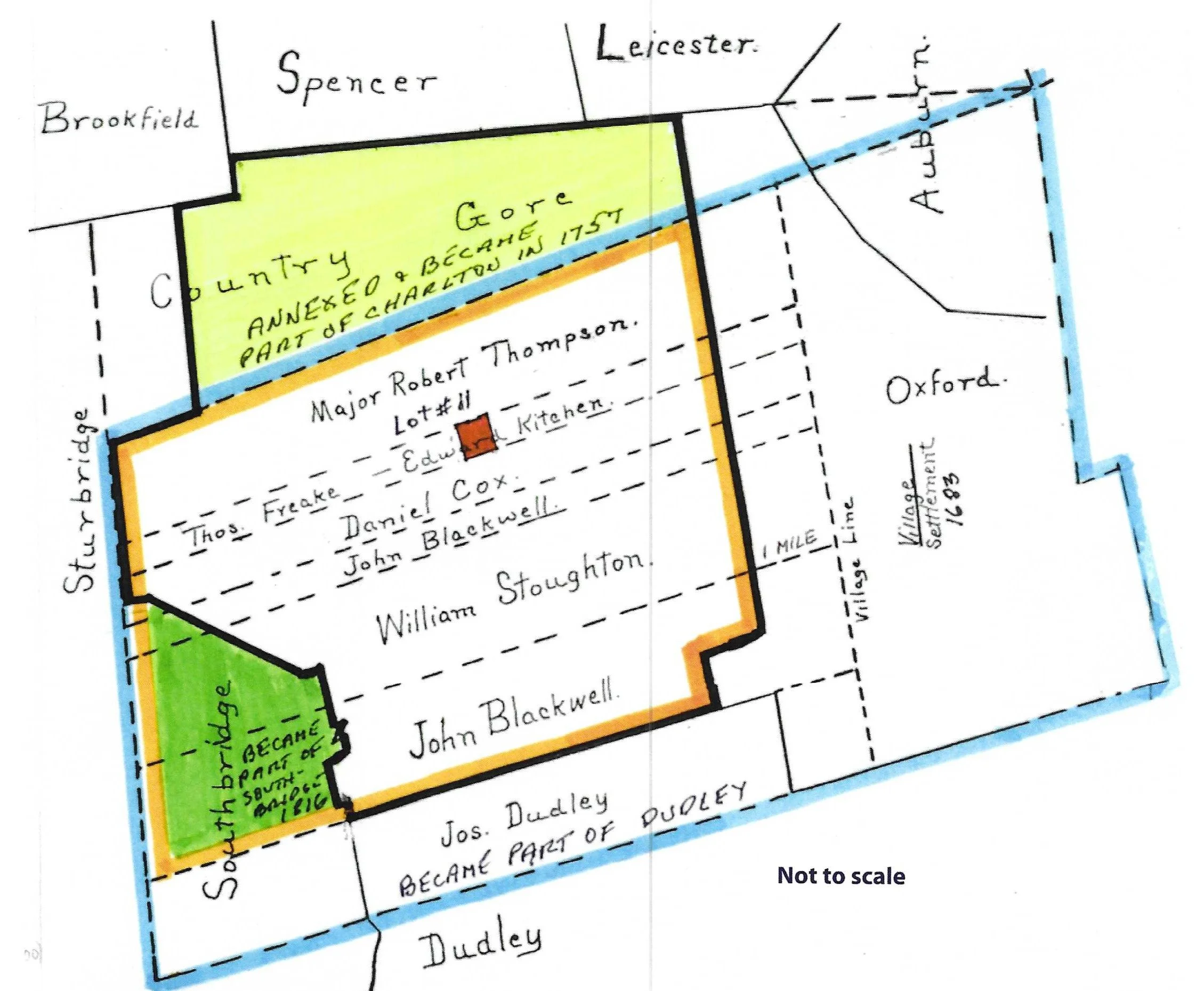
Map of Oxford 1683
This map of Oxford drawn prior to 1900 by an unknown person, survived on a glass plate negative. It was drawn, I believe, to show the formation and evolution of the Town of Charlton.
The blue border shows the original bounds of the Town of Oxford in 1683. The orange border shows the bounds of the Town of Charlton as set forth in 1755. The area highlighted in yellow, part of the Country Gore, was annexed and became part of Charlton in 1757. The area highlighted in green was taken from Charlton in 1816 and became part of the Town of Southbridge. The heavy black border encompasses what is close to the present day bounds of the Town of Charlton.
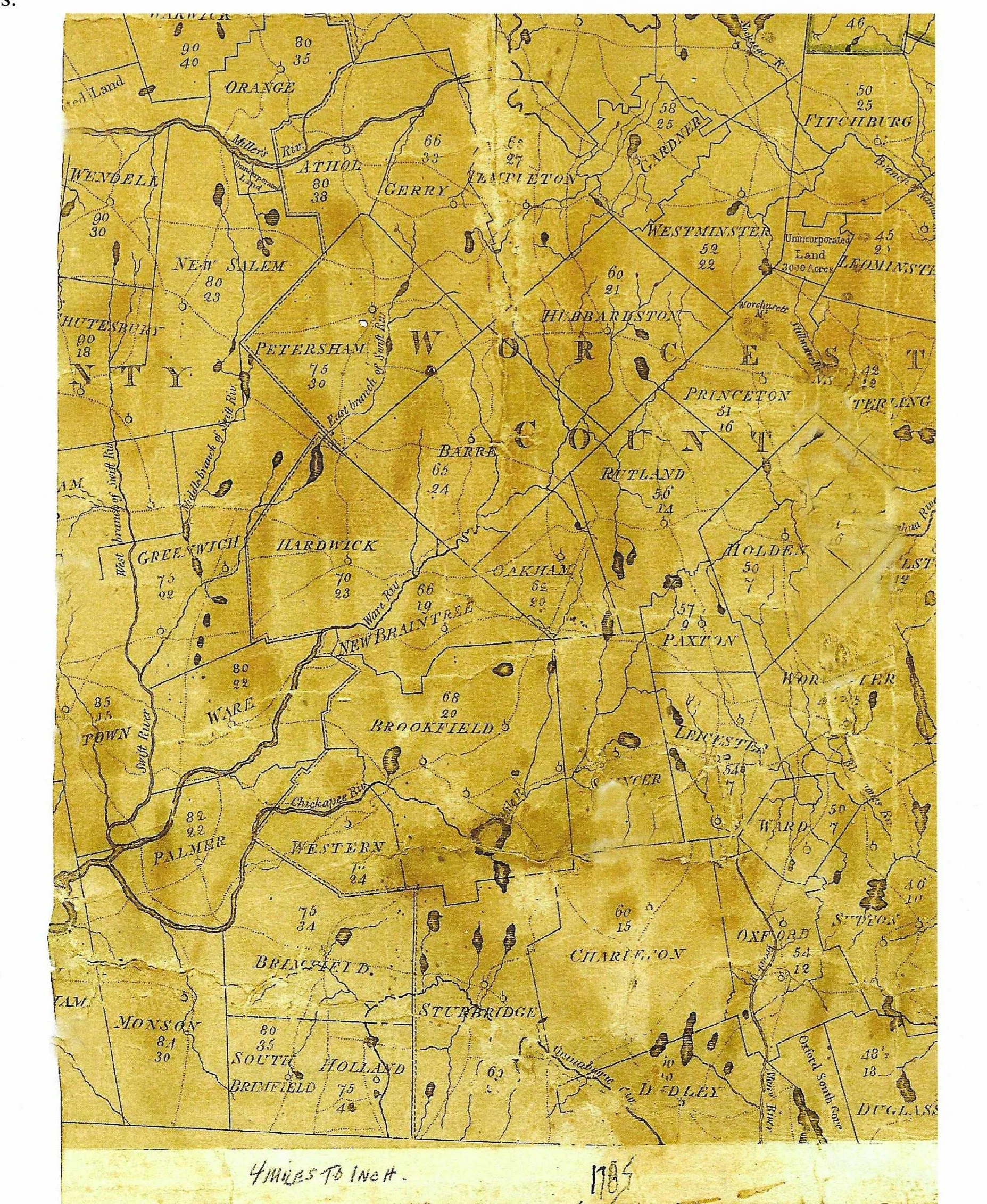
This 1785 map shows the early layout of Charlton and surrounding areas, including key roads, property divisions, and early landmarks. It provides a snapshot of how the town looked in the late 18th century, only a few decades after its incorporation.
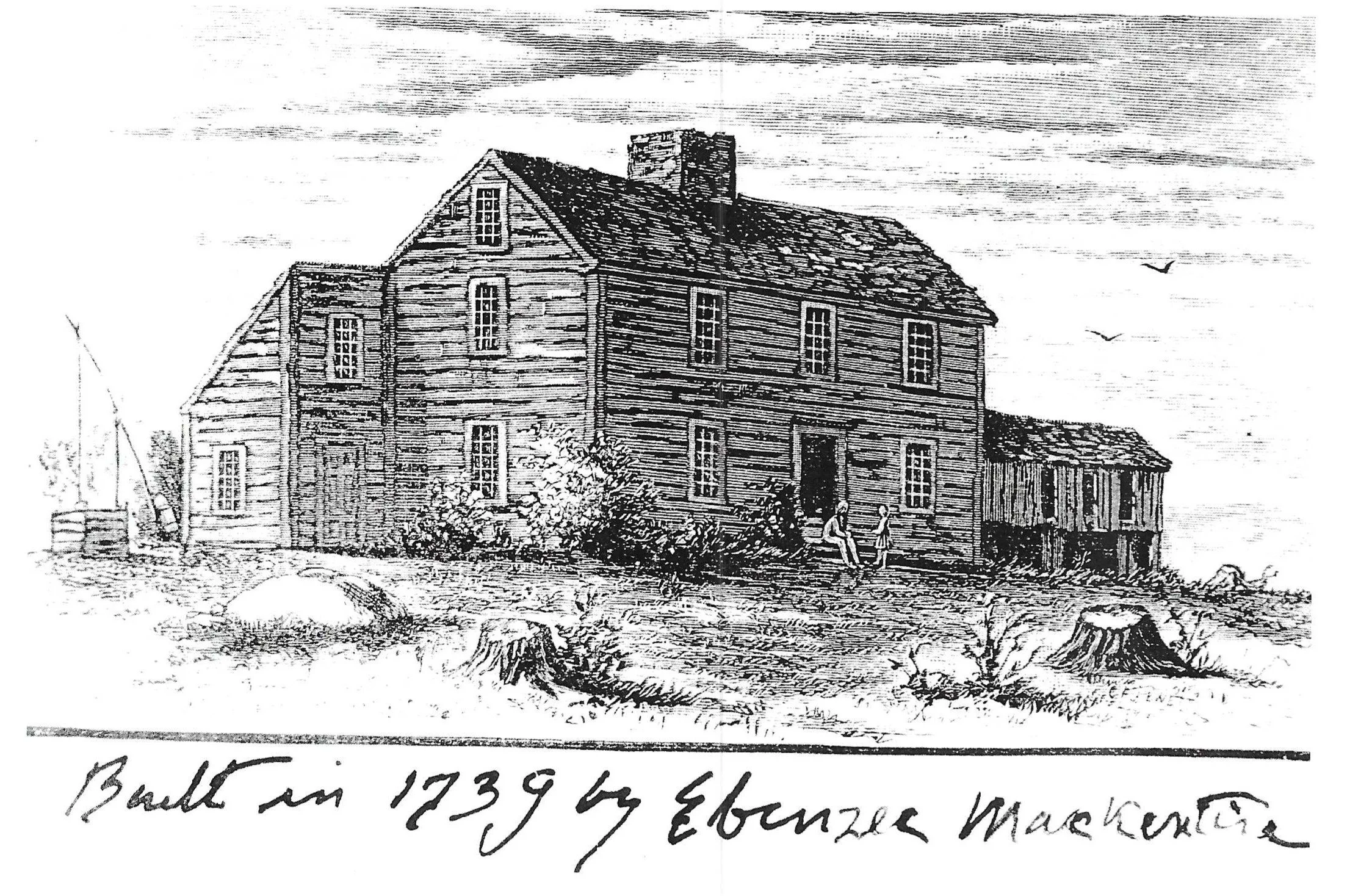
Possible Mackintire (McIntire) House
This copy of a pen and ink drawing of an early center chimney, two story house was found in the Melvin M. Baker collection of historic material. The name of the artist on the drawing is illegible and it is believed the caption was added by Melvin Baker. Ebenezer McIntire did build the first house in Charlton Center, probably about 1739, it was located on the south end of what is now Charlton Common, it probably faced south with the road passing to the east of it.
The house not only served as a residence for the McIntire family but was also a tavern and a Town meeting place. Noted local historian, William O. Hultgren believes the McIntire house would most likely have been a “Cape” style house and this view was conjecture by Melvin Baker. It was also noted in our own archival records that the Ebenezer McIntire house was taken down in 1850 but this cannot be corroborated except for the fact that it is not shown on the inset map for Charlton Center on the 1857 wall map of Worcester County.
The act creating the Town of Charlton was passed on January 10, 1755 by the State Legislature. The remainder of this account is written by the Hon. Rufus.B. Dodge as part of the Chapter XCV, CHARLTON in the History of Worcester County, Massachusetts, etc. compiled by D. Hamilton Hurd in 1889. The following record is the earliest account of building construction in the Town of Charlton. Be aware of the elapse time from start to finish.
By virtue of a warrant from Moses Marcy, of Sturbridge, issued by order of the General Court to John Dresser, a principal inhabitant of the district, “the freeholders and other inhabitants” were warned to meet at the house of Ebenezer McIntire on the 12" day of March, 1755, to choose such town officers as the law required.
On the 27" day of March of the same year, the second district meeting was held.
In April following it was voted “that the centre of the district should be the place to build a meeting-house upon, if a convenient place, and if not, the nearest convenient place to the centre should be the place to build upon.”
As soon as the district was organized the work of building a place of public worship and of providing schools was undertaken, but beyond deciding that the centre of the district should be the place to build a meeting-house upon and making slight provisions for schools nothing was accomplished. Timber for a meeting-house had been prepared before the separation from Oxford. The warrant for a meeting to be held December 8,1755, contained an article as follows: “To see if the district will agree to build a meeting-house, and if so, to agree upon the bigness to build the same;” and also the following: “To see if the district will choose a committee to take care of the timber that was hewed some time ago for a meeting-house, as also to provide materials for the same as may be thought most convenient if the district agree to build a meeting-house.” At the meeting held under this warrant it was voted to take no action on these articles; and at a meeting held February 7, 1757, it was voted to raise no money for schools or for the support of the Gospel, for the reason probably that it was expected that the petition that had been presented to the General Court for the annexation of the Gore would be granted.
June 3, 1757, a committee having considered the matter, reported that the petition ought to be granted. . “The report was read and accepted, and ordered that the inhabitants of said Gore and the land within the bounds petitioned for, be, and hereby are, annexed to the district of Charlton and made part thereof, to do duty and enjoy privileges as the other inhabitants of said district do or by law ought to enjoy.”
With the addition of population and resources secured by the addition of territory, the inhabitants considered themselves in a condition to carry on successfully public affairs. Accordingly, July 28, 1757, a meeting was held.
The district also voted “to build a meeting-house at the center of the district, if a convenient place; if not, at the nearest convenient place thereto.” The district before the Gore was annexed had passed a similar vote, but the large addition of territory made it necessary to select a new location, but failing to agree as to where the center of the district was or the nearest convenient place thereto, at meeting held November 22, 1757, a committee was chosen, consisting of Dea. Thomas Wheeler, of Worcester, Samuel Chandler, Esq., of Woodstock, and Col. Hezekiah Sabin, of Thompson, “to state a place for a meeting-house.”
An article in the warrant for a meeting held January 16, 1758, was as follows: “To see if the inhabitants of the district will vote that the meeting-house shall stand at a stake that is set up north of Ebenezer MclIntire’s house, and if not, to see if the inhabitants of the district will agree in sending to the General Court for a committee to find the centre of the district, and to state the place for the meeting-house.” At this meeting it was voted “to build the meeting-house at the stake a little north of Ebenezer McIntire’s house.”
Ebenezer McIntire gave the district an acre of land, but it was stated in the deed that it was for the use of said district “for the meeting-house to stand upon and for a training-field, and for no other uses.” This piece of land, as described in the deed was twenty rods long and eight rods wide and bounded easterly by the road.
The first meeting for the choice of district officers after the Gore was annexed was held March 20, 1758. At this meeting Jonathan Tucker,...
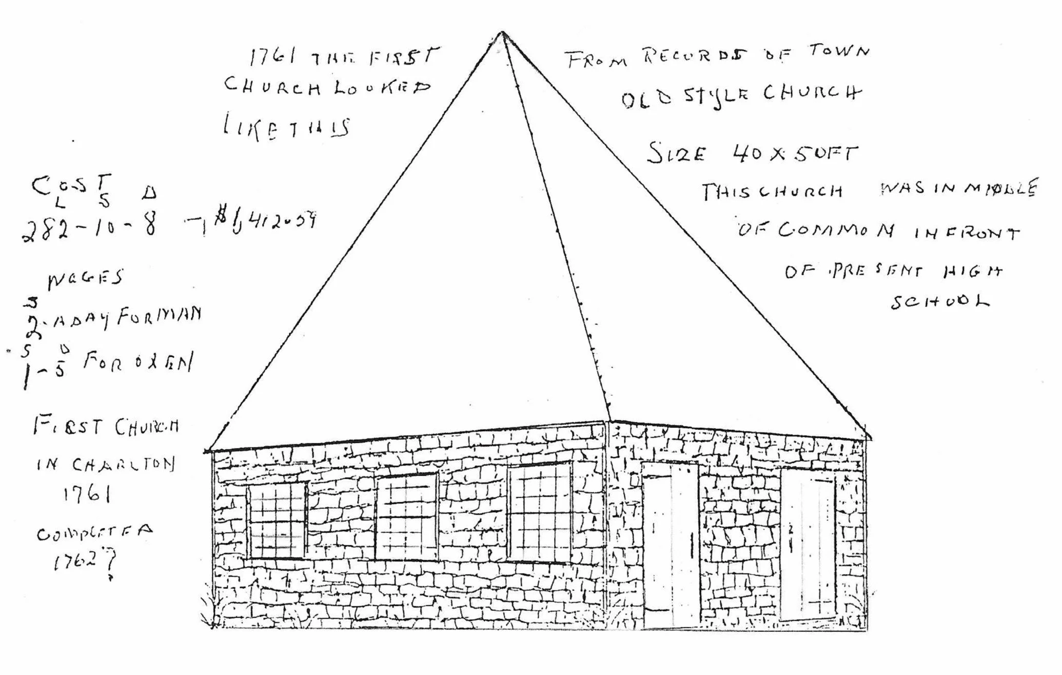
At the same meeting it was voted to build a meeting-house fifty feet long and forty feet wide and to cover the whole with shingles. One hundred pounds was granted toward the expense of building and Nathaniel Blood, Isaiah Blood, Jonathan Upham, Jonathan Ballard and Ebenezer Hammond were chosen a meeting-house committee for the year and were authorized “to set a price upon materials and upon labor and to choose a master workman to set up the frame.” In July, 1759, it was voted “to let out the framing of our meeting-house by the great,” and for twenty-six pounds, thirteen shillings and four pence, Jonathan Upham undertook “to set up the frame and assist in raising the same.” In September following the district voted “to provide a victuals and drink for the raising of the meeting-house and other necessaries,” and a committee was chosen to see that provisions were suitably prepared. In March preceding forty pounds had been voted toward defraying the charges of building. In 1760, upon the petition of Jonathan Tucker and other residents of the district, a tax of two pence per acre for one year on land of non-resident proprietors was granted by the General Court “in order to enable the inhabitants to finish the meeting-house.”
Although not completed, the house was in a condition to be used as a place of public worship by January, 1761. A meeting of the inhabitants for district business was held in it January 6. There had been expended upon it, as reported by a committee, two hundred and eighty-two pounds, five shillings, three pence and two farthings. In February following twenty pounds was voted “toward finishing the meeting-house.”
Afterward money had been voted from time to time for the support of the Gospel and meetings had been held probably at the house of Ebenezer McIntire, where all meetings for the transactions of district business were held until the meeting-house was in a condition to be used. In 1762 the district voted to put pillars under the gallery beams and to build seats from alley to alley, and appropriations were made from time to time to pay expenses. In 1772 the district voted to give Jacob Davis 163p 12s, to finish the inside of the meetinghouse, “the work to be done as well and complete in all respects as the work was done in the meetinghouse at Oxford and to be completed in eighteen months.” This building is presumed gone by 1857; it is not shown on the inset map of Charlton Center which was part of the wall map of Worcester County published that year.
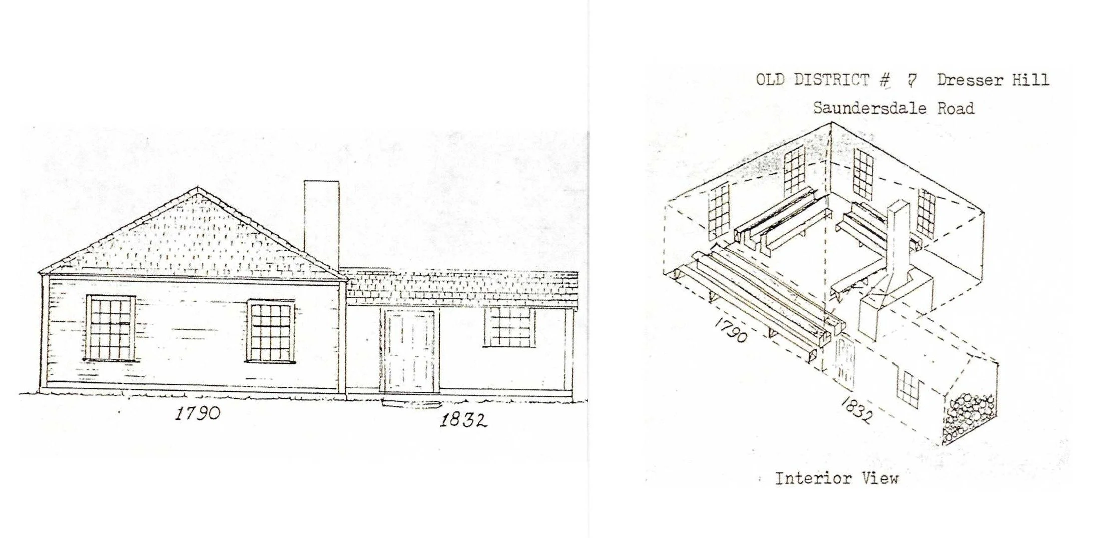
Located in the Historical Society archives is a notebook that contains the meeting minutes for the “District No. 8” school district for the time period March 17, 1790 through October 9, 1843. Using a few excerpts from this account we will get some insight into the construction of the second generation of schoolhouse in Charlton.
Earlier, a school had been built on Dresser Hill, perhaps as early as 1760, for a vote was taken at the first meeting entered into this book “to build a schoolhouse in said Ward, 24 feet square near where the old one stands.” The school district voters then instructed Capt. Free Comings, Lt. Josiah Blood and Moses Dresser to sell the old school and use the proceeds toward building the new schoolhouse as shown in the illustration. Moses Dresser agreed to “set up the frame of the new school at his own cost.” David Dresser built the chimney; Benjamin Dresser furnished the boarding; Isaiah Blood furnished shingles; and James Dresser lathed the schoolhouse — all at no cost.
The school was built in 1790. In November of that year, the “inhabitants of the south ward met to agree upon some method to finish the inside of the schoolhouse.” They voted “to build two Seats on Each Side of Sd house for Writers and one in the front and one Teere of Seats for Small Scollars all Round Within the Compas of the other side.
The account also indicates that in 1832 an ell extension was added to the school to store fire wood and a “necessary”.
This schoolhouse was built on the north side Saundersdale Road very close to Dresser Hill Road. The southeast and southwest school wards, now referred to as districts, were divided and the south ward added in 1780. The new ward included all of Dresser Hill to Dudley and a mile east and west of the schoolhouse. The south ward became District No. 8 in 1822 and finally became District No. 7 in 1838. This schoolhouse was in use until about 1888, when it was replaced with a new one room school.
In this catalog we have photographic evidence of two surviving examples of this type of schoolhouse construction. One is District No. 9, located on Tinker Hall Road X2, thought to be built about 1808. The second is District No. 10, located on Schoolhouse No. 10 Road X1, built about 1799. The accompanying illustrations where drawn by William O. Hultgren.
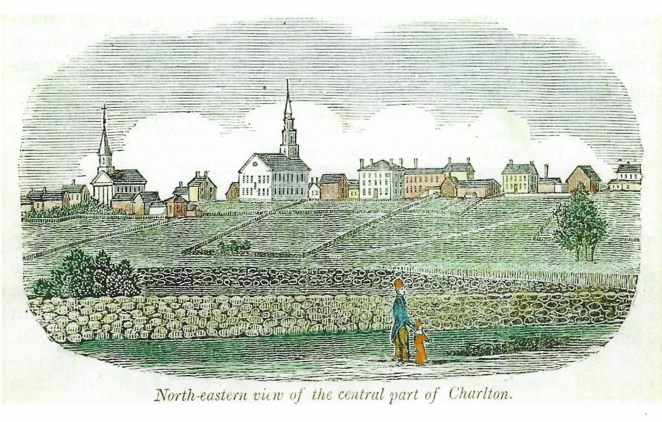
This is a sketch of Charlton Center drawn by John Warner Barber about 1830. He would travel through the Commonwealth doing sketches of town centers. This sketch gives us a sense of what Charlton Center looked like at that time, including the meeting house, surrounding homes, and the general arrangement of the village.
In 1830 the Commonwealth of Massachusetts required each town to submit a current map of the town showing roads, streams, mills, schoolhouses, hotels, stores and meeting houses. Burton Freeman was the surveyor and this is the map that was published in 1831. Most all areas of the town were accessible by a road, though they were gravel roads and the great majority was probably about one wagon width wide. As depicted on the map this was an inventory of none residences: 24 mills, 15 schoolhouses, 5 hotels (inns), 4 stores and 3 meetinghouses were located. If one looks real closely, four areas were community centers, circled in blue on the map: Charlton Center, Charlton City, Northside and Dresser Hill. Two have survived and the other two have not.
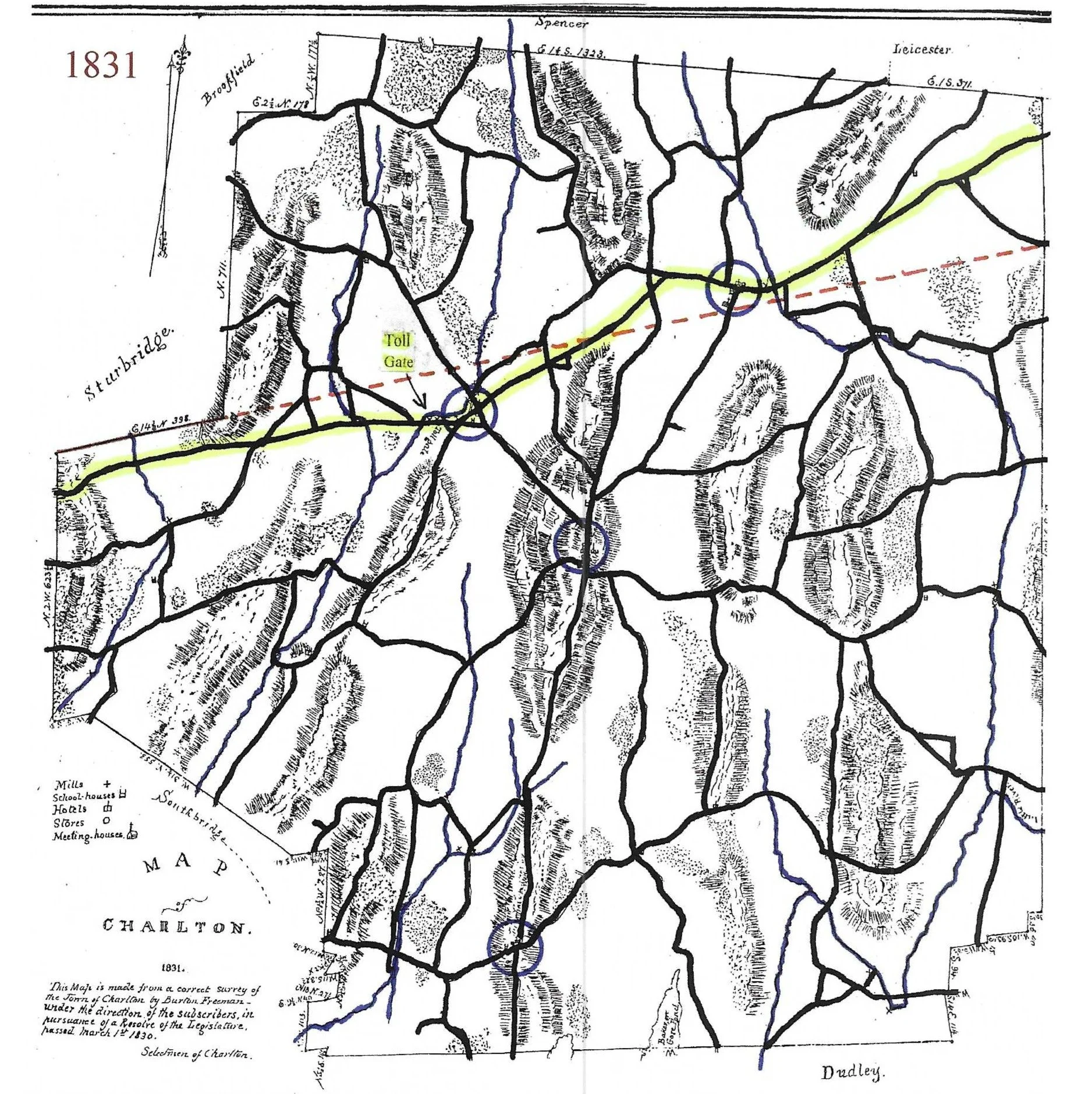
The dotted red line represents the Gore line; all the land north of it was originally part of Country Gore, which became part of Charlton in 1757. The yellow highlighted line was the road which became the Worcester — Stafford Turnpike; it was completed in March 1810 and was operated as a toll road until about 1834. The toll gate as seen on the map was just west of Charlton City.